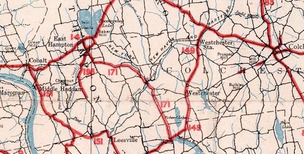
In 1932, state highways connected East Hampton to Haddam and Moodus, but not Colchester.
In 1932, when the state laid out many of the highways we still see today, there was no Route 16. There was not even a complete improved east-west highway from Portland to Colchester.
To make your way across in those days, you would take an assortment of narrow, crooked roads:
- Long Crossing Road (known as the "Swamp Road")
- an older version of Middletown Avenue (most traces of this are gone)
- an older Colchester Avenue (part of Route 171) to Comstock's Bridge. Bridge Street is part of the old alignment.
- leaving Route 171 along an older alignment (including Loomis Road) heading to Colchester
A few part of what would become Route 16 were on the state highway system:
- Colchester Avenue, from Main Street to Waterhole Road: the old Route 171
- short segment of Middletown Road in Colchester, near Scofield Road (SR number unknown)
- short segment of Middletown Road in Colchester, near Cabin Road (SR number unknown)
Nonetheless, the need for an improved road to Colchester was apparent.
Main Street to the Comstock Bridge: 1933
The first segment to be improved, completed in mid-1933, was 3 miles of highway from Main Street to the Salmon River in East Hampton, including a new bridge downstream from the Comstock covered bridge. The new road was 20 feet wide, with 5-foot shoulders.
Comstock Bridge to Colchester: 1934/35
In late 1933, bids were released to improve the 6 miles from Comstock Bridge to Route 85 in Colchester. This was known as the "Comstock - Colchester Trunk Line", under construction in 1934. There's not much trace of the old route, except for Loomis Road near Route 149.
Route 16 itself was designated in 1933 or 1934, and might have followed the completion of one or both segments. It picked up some miles from the old Route 171: Colchester Avenue from Main Street in East Hampton to Waterhole Road. Route 16's original length was 12.03 miles, from Route 66 in East Hampton to Route 85 in Colchester.
Today's Route 66 was called Route 14 at the time, and Route 16 was a decent number for an easterly branch.
Route 14 to Main Street: 1939/40
The "Swamp Road" is mentioned a lot in 1930s newspapers, but not on maps. I think it's Long Crossing Road, but there's also a mention of a point 300 feet southwest (not north) of Middletown Avenue. In any case, the westernmost segment of Route 16 followed Long Crossing Road, a substandard road crossing a railroad and reaching Route 14.
The new Route 16, entirely south of the railroad, was a 2.5-mile segment leading from Johnson's Bridge (aka the Black Bridge) over the railroad to Main Street in East Hampton. It was started in June 1939, and finished around 1940.
Colchester to Lebanon: 1963
The portion of today's Route 16 east of Route 85 was added as a state road – SR 679 – in 1949. In 1960, SR 679 was renumbered to SR 658.
In 1959, a bill was submitted to add a segment of Lebanon Avenue in Colchester to the state highway system.
On March 29, 1963, Route 16 was extended over SR 658 to Lebanon.
Open questions
- date Route 16 was designated
- opening date for the 66 to 196 segment
- where exactly the Swamp Road was
- Old Middletown Avenue's name implies an old alignment, but no details yet
- the SR numbers for the tiny 16 segments in Colchester


 Screenshot of 1981 arcade game "Route 16", courtesy of www.mame.net